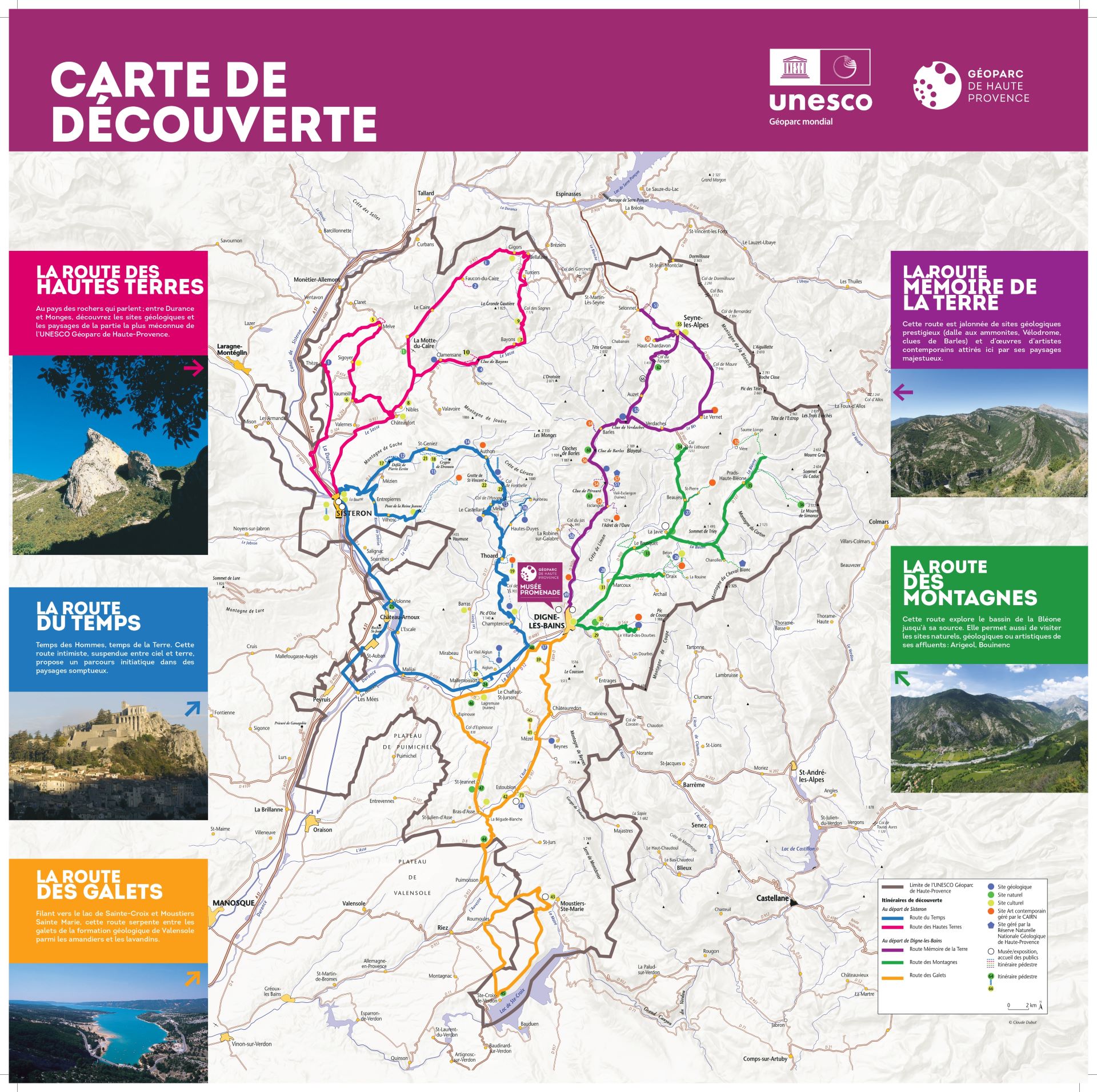


Five discovery routes wind their way through the Geopark’s emblematic heritage sites and sumptuous landscapes. Each of these routes reveals geological and cultural treasures, inviting you to explore the region in an enriching and immersive way.
Discovery routes
POILROUX Florence

Gaudichart private refuge

Ecolodge 04

Bed and breakfast : Le Pin des Arches

The Bear Fountain

Reconnexion Nature bivouac and trekking guide

Association for the promotion of the Sarteau de Draix pear
Provence Gourmande – Chef Frédéric Payan
Association Intercommunale de Défense de l’Environnement (AIDE)

Atelier Bondil

Sisteron discovery trail: time trail

The Road of Time
Le Vallon des Eaux Chaudes

Gite T2 Halte Air et Go – L’hôte antique

Cyclo n°3 – Vallée de l’Asse

Hannibal’s Pavilion
The philosophers’ summit

Edge-stone or medium mountains

La Sirène du Bès

Roche Rousse Sanctuary

Windows by herman de vries

Panorama du Blayeul

La Javie orchards

Panorama Saint-Michel

Le Parc forestier du Brusquet

Panorama du Col d’Hysope

Panorama de Lagremuse

Panorama of Champtercier

Le Puy panorama

Panorama du château

Pineapple oak

The panorama of Beynes

Le Chêne Pierre d’Arc

Bras d’Asse lime kiln

The Thoard gypsum quarry

The rock of Sainte-Madeleine
The Trente pas factory

Saint-Etienne Church
The Pinées mine

Our Lady of Liesse

The Lagremuse ruins

La Chapelle Saint-Jean

The EDF canal

The Manosque canal

Gypseries at Volonne castle

The ruins of Saint-Jean church

La Chapelle Saint-Christol

Les Mélèzes de Chourges

Panorama of Lac de l’Escale

The Fontchaude spring

Bird footprints

The dumpling ravine

The Barles slate quarries

The clue de Sisteron

Le Vieil Aiglun

Gaubert rock church

The mine gallery

Le Hameau de la Rouine

Our Lady of Lauzière

The bell tower of Thoard

The annalematic sundial

Our Lady of the Rosary

Our Lady of Bethlehem Church

Melve Tower

The Written Stone

Fountain of Gigors

Queen Jeanne Bridge

Chapel and crypt of Dromon

Malijai Castle

The 16th-century Château de Château-Arnoux

Notre-Dame du Bourg Cathedral

Apartment T6 Le Château

Apartment T3 Hypocras

Holiday cottage T4 Bélà Vista – La Bastida Flora

Le Jas de Volonne

Gite T3 Halte Air et Go – Cheval Blanc

Gite T3 Halte Air et Go – Barre des Dourbes

Apartment T2 Près des étoiles

Apartment T2 La Bergerie

Apartment T3 Les Robines

Apartment T4 Le Fournil

Unusual accommodation Le Pigeonnier
Gîte T3 La Bédigue La Ferme du Château

Lou Cèu Sin

Luc Richard – Hiking in the mountains

Gîte T4 La Maison blanche

Flower camping Le Clôt du Jay

Musée Édith-Robert – Musée Terre et Temps

Gallo-Roman Museum

Sisteron Country Ecomuseum

Camping Les Prairies***

Gîte du Levant (T3) – Le Vieil Aiglun

Gîte du Couchant (T3) – Le Vieil Aiglun

Gîte du Midi (T5) – Le Vieil Aiglun

Apartment T3 Le Galabre

Camping Les Eaux Chaudes

Hotel Saint Michel

Louis Teyssier hiking guide

La Robine des Canards

Bleu d’Argens – Distilling happiness

Tis’ânes, Alps and Luberon Nature Stays

Association Intercommunale de Défense de l’Environnement

Annie’s great story

La Ferme du Rouveyret

Pasta Durance

Brasserie de l’Aubrée

Le Maurier

Auberge Montagnarde du Fanget

Fort Vauban de Seyne
GAEC l’Étoile du Berger & Association pour la promotion de la Poire Sarteau de Draix

Other slopes – Mountain leader – Simon De Bergh

GAEC La ferme du Château

Wild and Wooden Basketry

Le Cabanon

The 28

Le Champ des Ombelles

Gîte Lou Cèu Sin

Chef Frédéric Payan- Cuisine et terroir

Hiking France

Via Ferrata de la Grande Fistoire

Ferme des Sagnes

Adoux products

Dinovol Paragliding

The treasures of our mountains

Les Chevaux de Roquépine horse farm

Art en Chemin

Ecomuseum La Javie

GAEC La Tchiote Bédigue

Hotel Tivoli Théopolis

Hôtel-Restaurant Le Vieux Tilleul***** (hotel-restaurant)

Mandala Voyages

Camping Mandala

Via Ferrata de la Falaise de Meichira

Villa Gaïa Hotel & Pension

Via Ferrata du Rocher de Neuf Heures

Lavender Museum

Karkam Provence Saffron

La Maison du Mulet

Le Vieux Moulin

Camping du Moulin de Thoard

Chez Le Poète** Hotel-Restaurant

Les Ruchers de la Bastide Blanche

Gîte Lavande

Gîte de Flagustelle
The Earth Memory Route
The Memory of the Earth Route winds its way up the valley of the Bès to that of the Blanche. From Carboniferous rainforests to the traces of Quaternary glaciers, 300 million years of history are on display in this sumptuous landscape that has attracted renowned artists.
The starting point for the Memory of Earth Route is the Musée-Promenade, an excellent introduction to the Unesco Geopark of Haute-Provence. The ammonite slab, a true symbol of our region’s geological wealth, is the first site to welcome you. The road then winds along the increasingly wild Bès. The scenery changes at every bend, sculpted by a tormented geology. The road criss-crosses narrow, winding creek valleys, carved out of the rock by the torrent. The valley finally widens between Blayeul and Pic des Têtes. The Col de Maure gives access to the Seyne basin. After a detour through Selonnet, the road takes you back to Digne via the Col du Fanget.


The Mountain Route
La Route des Montagnes explores the Bléone basin and its tributaries upstream of Digne-les-Bains.
Departing from Digne-les-Bains, in the Eaux-Chaudes valley, it allows you to discover the Saint Pancrace massif on foot, overlooking the Thermes and Saint-Jean chapel. After Marcoux and the panoramic view from Saint-Michel over the upper Bléone basin, it climbs to the village of Draix, from where you can hike to the Refuge d’art de Bellon overlooking the Terres Noires. From La Javie, it’s on to Prads-Haute-Bléone and its hamlets nestling at the foot of l’Estrop and Cheval Blanc. Then on to Beaujeu and the Col du Labouret, where the Demontzey park showcases over a century of reforestation work. Two very different mountain environments.
La Route des Galets
The Route des Galets takes its name from the huge accumulations of material brought by rivers at the end of the Tertiary Era to what is now known as the Digne-Valensole basin.
The Route des Galets leaves Digne-les-Bains for the Asse valley. At La Bégude, the road leaves the Asse to climb to the Valensole plateau and its lavender fields. It leads to Moustiers-Ste-Marie. It winds its way through the narrow streets of the earthenware capital before climbing back up to the plateau overlooking the turquoise waters of Lac de Sainte-Croix. Above the village of Sainte-Croix-de-Verdon, admire this dazzling landscape one last time before turning your back on it in the direction of Puimoisson. The route returns to Digne les Bains via the Col d’Espinouse and Le Chaffaut. A total loop of 125 km.


La Route du Temps
The starting point for the Route du Temps is in Sisteron, in front of the Musée Terre et Temps. A visit to this museum will help you understand the gap between Earth time and human time. It’s this gap that geologists are trying to bridge.
After the clue de Sisteron, the Route du Temps winds its way between the Gache and Baume mountains, offering fine views over the Durance basin. Crossing the Chardavon gorge, the Route du Temps enters the peaceful Vançon basin. The Col de Fontebelle offers a change of valley and a shady spot for a stopover in summer. The Route du Temps then zigzags through the Duyes valley towards the perched village of Thoard. Take the time to stop and stroll up to its keep and bell tower. The route then joins the Bléone valley, passing through Champtercier, home of the philosopher Gassendi. After Malijai, return to Sisteron via either bank of the Durance.
The Highlands Road
The Route des Hautes Terres invites you to discover the Motte du Caire region on the back roads north of Sisteron.
The Route des Hautes Terres offers a wide variety of atmospheres. It follows the course of the Durance, crossing a hilly landscape on small roads before descending to the Sasse valley. Then it’s on to Cairo country and its via ferrata. The valley narrows at the Col de Sarraut. We then head north. A new pass, Les Sagnes, and the route returns to the course of the Sasse as it descends the Tourniquets d’Astoin. The wide Bayons basin comes into view, before the clue of the same name chokes the path. Finally, the Route des Hautes-Terres takes you back to Sisteron via the faubourg de la Baume. You’ll discover the imprint left by glaciers and breathtaking landscapes.

Discovery routes map