


Le Pavillon d’Hannibal
Cette œuvre de Trevor Gould, dans un hameau du Vernet, fait référence au possible passage d’Hannibal, en 218 av J.-C, alors qu’il s’en allait défier Rome… Le célèbre général carthaginois Hannibal aurait pu passer par le col qui surplombe le site de « Passavous de Laou ». C’est en tout cas ce que suggère cette […]
Le sommet des philosophes
Le sommet des philosophes s’inscrit dans le projet « traces » d’herman de vries*. Il est l’une des œuvres de la collection Art en montagne développée par le musée Gassendi et le CAIRN Centre d’art. herman de vries a gravé, depuis 2001, un ensemble d’inscriptions en divers lieux du territoire du Géoparc de Haute-Provence. Ce […]

Edge-stone ou les moyennes montagnes
Le CAIRN, Centre d’art contemporain reconnu d’intérêt national, invite des artistes à créer in situ sur le territoire du Géoparc de Haute-Provence. Grâce au CAIRN, les sites naturels deviennent de véritables objets de création et ne sont plus seulement des décors. En œuvrant in situ, les artistes créent en résonnance avec le territoire et ils […]

Les Fenêtres d’herman de vries
A travers l’installation artistique réalisée à la surface de ces roches, herman de vries ouvre une fenêtre sur le passé et l’invisible, nous donnant accès à une série de formations géologiques. herman de vries* est venu pour la première fois à Digne-les-Bains en 1999 sur une invitation du CAIRN centre d’art. Depuis, il est revenu […]

© ©UGPH
La Sirène du Bès
A l’invitation de Joan Fontcuberta, découvrez Les hydropithèques, mi-animaux, mi-humains, dont les squelettes furent retrouvés dans les années 1950 sur l’actuel territoire du Géoparc de Haute-Provence… Les œuvres de l’artiste Joan Fontcuberta proposent une analyse critique des techniques de l’information et de la communication et nous invitent à nous interroger. La sirène du Bès fait […]

Le Sanctuaire de Roche Rousse
Le sanctuaire de la nature d’hermann de vries* montre le processus de reconquête des ruines abandonnées par la nature. Il s’inscrit dans une démarche artistique globale, portée sur et par le territoire depuis plus de vingt ans. Tout change, la vie est changement et métamorphose, nos traces sont éphémères… Le sanctuaire de la nature de […]

© ©UGPH
Panorama de la montagne de Mélan
La montagne de Mélan culmine à 1708 mètres d’altitude avec le pic de Cluchette. Elle ferme au nord la vallée des Duyes et annonce le massif des Monges, au cœur du Géoparc de Haute Provence. La montagne de Mélan constitue un excellent poste d’observation sur la vallée de la Durance et les montagnes provençales. Plein […]

le panorama du Vanson
Le panorama du Vanson (ou Vançon) offre l’une des plus belles et plus instructives vues du Géoparc de Haute Provence. Il permet de comprendre une partie de la longue histoire géologique de la région. Vous pourrez observer deux unités géologiques bien distinctes. La première concerne les terrains autochtones (qui n’ont pas été déplacés) datant du […]

© ©Dronedescimes
Panorama du Blayeul
Depuis la vallée, au parc forestier du Brusquet, l’observation du Blayeul permet de comprendre une partie de l’histoire géologique du territoire. Montagne tutélaire de la moyenne Bléone, la montagne de Blayeul apparaît telle une puissante croupe séparant les vallées de la Bléone et du Bès. Aujourd’hui infranchissable en empruntant une route carrossable, le massif était […]

© ©UGHP
Le Panorama Saint-Michel
La colline Saint-Michel, entre Bléone et Mardaric, est l’un des sites d’interprétation du Géoparc de Haute-Provence. Elle vous offrira un large panorama sur la vallée de la Bléone. La Bléone, qui traverse le Géoparc, est longue de 67 km depuis le massif de l’Estrop jusqu’à sa confluence avec la Durance. Vierge de tout aménagement sur […]

Le Parc forestier du Brusquet
Ce parc s’inscrit dans l’histoire de la restauration des terrains en montagne qui a permis de lutter contre l’érosion. Il est aujourd’hui un lieu de promenade et de découverte, qui vous offrira un moment de fraîcheur, d’évasion et de détente. Le bassin du Brusquet était, au milieu du XIXe siècle, presque entièrement dénudé. Les chênes […]

Les vergers de la Javie
Les vieux fruitiers dressent leurs silhouettes tortueuses en Haute-Bléone. Véritables sentinelles de la mémoire, ils suscitent aujourd’hui un regain d’intérêt, patrimonial et économique. Autour du confluent de la Bléone et de l’Arigeol, s’étendent de fertiles terres agricoles. Longtemps menacées par les crues mais très tôt irriguées par des canaux, elles furent consacrées, dès le XVIIIe […]

Le Panorama du Col d’Hysope
Le col de l’Hysope (1236 m.) offre une vue spectaculaire sur la vallée des Duyes. Ce panorama est le résultat d’un événement géologique important lié à la mise en place des Alpes. Vous pourrez embrasser du regard toute la vallée des Duyes dont la bordure orientale montre le chevauchement de la nappe de Digne sur […]

Le Panorama de Lagremuse
Depuis le hameau en ruine, la vue exceptionnelle sur la vallée de la Bléone et sa ceinture de sommets permet de comprendre la formation géologique du territoire. La vue embrasse toute la vallée de la Bléone et se découvre après une agréable marche. Son observation peut se découper en quatre ensembles, correspondant à des unités […]

© ©UGPH
Panorama de Champtercier
Depuis Champtercier, sous le ciel bleu de Haute-Provence, observez, comme le faisait autrefois le célèbre savant Gassendi, les montagnes dignoises pour faire le plein de sérénité… Ces terres sont le berceau du Géoparc de Haute-Provence, dont les paysages racontent une histoire longue de 300 millions d’années. Depuis Champtercier, de la Bléone jusqu’à la pyramide du […]

© ©UGHP
Le panorama du Puy
La colline du Puy constitue le point culminant de la commune d’Aiglun. Du haut de ses 900 m, elle offre une vue exceptionnelle sur les vallées et les sommets alentours. Elle est l’un des sites d’interprétation du Géoparc de Haute-Provence. La colline du Puy tient son nom du latin podium qui signifie petite éminence. Le […]

© ©️AD 04/Martin Champon
Le Panorama du château
Les vestiges du château médiéval se dressent au-dessus du village. Le belvédère permet d’observer un très beau panorama et de découvrir une partie de l’histoire géologique de la vallée de la Durance. La plus ancienne mention du château remonte à 1068 mais son existence est certainement antérieure. Véritable forteresse féodale, il fut presque entièrement détruit […]

© ©UGPH
Le panorama de Beynes
A 793 m. d’altitude, au cœur du Géoparc de Haute-Provence, le village perché de Beynes offre un panorama exceptionnel sur la vallée de l’Asse et raconte une histoire de la Terre. Le village se hisse au-dessus de la vallée de l’Asse, au sein du massif du Montdenier. Son occupation remonte à la Préhistoire et le […]

Le Chêne Pierre d’Arc
Le chêne de Pierre d’Arc est l’un des arbres remarquables recensés par le Géoparc de Haute-Provence. N’hésitez pas à faire une pause pour l’admirer : il est en bord de route ! L’observation des arbres est un exercice à pratiquer régulièrement, il invite à profiter de la nature qui nous entoure, à en prendre des […]

Le chêne Ananas
Le chêne ananas est l’un des arbres remarquables recensés par le Géoparc de Haute-Provence. N’hésitez pas à faire une pause pour l’admirer : il est en bord de route ! L’observation des arbres est un exercice à pratiquer régulièrement, il invite à profiter de la nature qui nous entoure, à en prendre des leçons de […]

© ©OT_Sisteron
Le rocher de la Baleine
Le rocher de la Baleine est une étape de la route du Temps, l’une des cinq routes de découverte du Géoparc de Haute-Provence. Il est le résultat d’une série d’épisodes géologiques. À quelques kilomètres du charmant village de Saint-Geniez, le Rocher de la Baleine stimulera votre imaginaire et celui des enfants. La mer recouvrant la […]

© ©UGHP
La grotte Saint Vincent
La grotte Saint-Vincent est une cavité naturelle profonde d’une trentaine de mètres, située sur la commune du Castellard-Mélan dans le massif des Monges. Avec sa salle principale, ses stalactites et ses bassins, la grotte Saint-Vincent ouvre sur l’inconnu du monde souterrain. Sa formation est due à la dissolution des calcaires du Jurassique par les eaux […]

© ©UGHP
Les conglomérats de Valensole

© ©Eric Olive/AD 04
Le chaos de la Piche
Ce glissement de terrain, situé sur la route des Hautes Terres du Géoparc de Haute-Provence, fait apparaître de manière spectaculaire les matériaux de différentes périodes géologiques. Le chaos de « La Piche » résulte d’un glissement de terrain, qui a débuté entre 1990 et 1994 et qui s’est étendu jusqu’en 2006, détruisant une partie des […]

Les slumps de Reynier
Ce site géologique se situe sur la route des Hautes Terres, l’une des routes de découverte du Géoparc de Haute-Provence, au cœur du pays de la Mémoire de la Terre. Le Géoparc de Haute-Provence présente des paysages et des curiosités géologiques qui fascinent les géologues mais qui charment, étonnent et intéressent de plus en plus […]

Le four à chaux de Bras d’Asse
Ce four à chaux se situe sur une route qui conduit du village de Bras d’Asse vers le hameau des Oraisonis. C’est un élément patrimonial remarquable, par sa façon et ses dimensions. Jusqu’à la révolution industrielle, chaque village ou presque comptait au moins un four à chaux ou un four à plâtre. La seule commune […]

© ©️AD 04/Martin Champon
La carrière de gypse de Thoard
Le gypse, qui permet de produire le plâtre, apparaît ici et là sur les flancs des collines du Géoparc de Haute-Provence. La carrière du Siron fut est restée en activité jusqu’en 1940. Le patrimoine bâti de Haute-Provence est indissociable de sa géologie. Ainsi, le plâtre a toujours été très utilisé sur ce territoire en raison […]

© ©️AD 04/Martin Champon
Le rocher de Sainte-Madeleine
Ce rocher (1 100 m.) est une curiosité géologique et un lieu culturel avec sa chapelle et son Refuge d’art d’Andy Goldsworthy. C’est aussi une horloge de pierre… Le rocher de Sainte-Madeleine représente une synthèse de la richesse des patrimoines du Géoparc de Haute-Provence. Il témoigne en effet d’une histoire géologique longue et mouvementée. Issu […]

© ©UGPH
Chapelle Saint-Armand
Depuis le village perché de Clamensane, la randonnée jusqu’à la chapelle Saint-Amand vous promet une vue superbe sur l’une des vallées emblématiques du Géoparc de Haute Provence. La chapelle Saint-Amand se trouve sur un site antique et domine la vallée de la Sasse. La crête sur laquelle elle fut construite marquait autrefois la limite entre […]
L’usine de Trente pas
Témoin d’une histoire économique révolue, l’usine hydro-électrique de Trente-Pas a fonctionné pendant plus de 60 ans. Autorisée par décret de 1938, l’usine utilisait l’eau prise dans la Bléone, au niveau du confluent de la Chanolette, puis amenée par un ouvrage de 4 km, comprenant aqueducs et siphons pour une chute d’environ 60 m. La puissance […]
La mine des Pinées
Située dans la clue de Verdaches, au cœur du Géoparc de Haute-Provence, cette mine rappelle qu’autrefois le sous-sol était exploité dans la région. La clue de Verdaches a été creusée par le Bès il y a près de 6 millions d’années dans des terrains du Trias (-235 MA) et du Carbonifère (-300 MA) qui comptent […]

© ©UGPH
Église Saint-Etienne
L’église paroissiale de Marcoux est un très bel exemple d’art roman rural. Son campanile lui donne un charme supplémentaire. La construction de l’édifice remonte au XIIe et XIIIe siècles. Elle dépendait alors du chapitre de la cathédrale de Digne. L’édifice, de trois travées voûtées d’un berceau à peine brisé débouchant sur une abside semi-circulaire, a […]

© ©UGPH
Notre-Dame de Liesse
La chapelle Notre-Dame de Liesse est un témoignage de la ferveur religieuse du XVIIIe s. mais également de la crainte qu’inspirait autrefois l’Asse, aux crues dévastatrices. La petite chapelle est édifiée entre la rivière et la route menant au hameau de Bellegarde d’Estoublon. Avant la construction du pont sur l’Asse (XVIIe), elle se trouvait sur […]

La Chapelle Saint-Jean
La chapelle Saint-Jean marque le site d’origine du village de Saint-Jeannet, dans la vallée de l’Asse. Elle est de belle facture architecturale et témoigne de la persistance de l’art roman en Haute-Provence. Parmi les architectures remarquables du Géoparc de haute-Provence, de nombreux édifices romans marquent le territoire. Vous pourrez découvrir de grandes églises mais aussi […]

© ©UGPH
Les ruines de Lagremuse
Le hameau en ruine surplombe la vallée de la Bléone et offre une vue panoramique. A ses pieds, une oliveraie centenaire lui donne un charme supplémentaire. Lagremuse dresse fièrement ses ruines pour résister encore un peu aux implacables assauts du temps. Le site témoigne encore de sa vocation défensive passée. On distingue quelques pans de […]

© ©UGPH
La Chapelle Saint-Christol
Cette belle chapelle remonterait au XIe s. Elle est dédiée à Saint-Christophe, patron des voyageurs et constitue une halte agréable sur la route Napoléon, entre Digne-les-Bains et Malijai. Construite sur un site antique correspondant aux ruines d’une ancienne villa gallo-romaine, la chapelle appartenait à l’abbaye Saint-Victor de Marseille. Voûtée à l’origine, elle a été maltraitée […]

© ©️AD 04/Martin Champon
Le canal EDF
Le Canal de la Durance traverse le territoire du Géoparc de Haute-Provence et marque l’empreinte de l’homme dans une vallée qui, de tout temps, fut une voie de circulation entre les Alpes et la Provence La Durance était au Moyen Âge le « troisième fléau de la Provence », après le Parlement et le Mistral ! […]

© ©UGHP
Le canal de Manosque
Bientôt centenaire, ce canal constitue un havre de fraîcheur et de bien-être. Il est indispensable à l’agriculture locale et très apprécié des nombreux promeneurs et randonneurs. Depuis sa mise en service, le canal de Manosque a révolutionné l’agriculture des 13 communes qu’il traverse en rive droite de la Durance, entre Château-Arnoux-Saint-Auban et Corbières-en-Provence. C’est également […]

Les gypseries du château de Volonne
Les gypseries du château de Volonne comptent parmi les plus belles de Provence. Elles rappellent la présence de gypse, servant à fabriquer le plâtre, dans le sol de Haute-Provence. Le château, construit en 1607 sur commande de Melchior de Valavoire, se dresse sur la place du village, flanqué de ses deux tours rondes. Il s’apparente […]

© ©UGHP
Les ruines de l’église Saint-Jean
En rive droite de la Bléone, le site de Saint-Jean est un lieu de promenade agréable. Son église, construite à la fin du XIe s., offre encore ses ruines, dans une ambiance hors du temps. Le site de Saint-Jean fut probablement occupé dès le Néolithique avec une fonction funéraire qui s’affirma au cours des siècles. […]

© AD04 Thibaut Vergoz
La Sentinelle d’Authon
Les paysages du Géoparc de Haute-Provence sont une source d’inspiration pour un grand nombre d’artistes, de renommée internationale. Parmi eux, Andy Goldsworthy tient une place particulière. Au sein du Géoparc de Haute-Provence, des artistes ont créé depuis 2000 avec le soutien du CAIRN centre d’art, des œuvres révélant les spécificités naturelles, historiques, culturelles, sociales du […]

Refuge d’Art « La Forest »
Dans le cadre de son œuvre globale Refuge d’art, installée au cœur du Géoparc de Haute-Provence, Andy Goldsworthy a investi le hameau abandonné de la Forest, sur la commune de Saint-Geniez. Refuge d’Art est une seule œuvre d’art conçue par l’artiste britannique Andy Goldsworthy en partenariat avec le musée Gassendi et le Géoparc de Haute-Provence. […]

© Le Naturographe
Refuge d’Art « Le Vieil Esclangon »
Le vieil Esclangon, frappé par l’exode rural, était abandonné et en ruines. Il héberge aujourd’hui l’un des sept Refuges imaginés et créés par Andy Goldsworthy, artiste de renommée internationale. Refuge d’Art est une seule œuvre d’art conçue par l’artiste britannique Andy Goldsworthy, en partenariat avec le musée Gassendi et le Géoparc de Haute-Provence. Ce parcours […]

© Le Naturographe
Refuge d’Art « La Ferme Belon »
La ferme de Belon, haut lieu de la Résistance, est l’un des sept Refuges imaginés et créés par Andy Goldsworthy, artiste de renommée internationale. Refuge d’Art est une seule œuvre d’art conçue par l’artiste britannique Andy Goldsworthy en partenariat avec le musée Gassendi et le Géoparc de Haute-Provence. Ce parcours unique en Europe traverse sur […]

Refuge d’Art « Col de l’Escuichière »
Dans le cadre de son œuvre globale Refuge d’art, installée au cœur du Géoparc de Haute-Provence, Andy Goldsworthy a créé ici deux œuvres, s’inspirant des pierres calcaires noires veinées de calcite blanche. Refuge d’Art est une seule œuvre d’art conçue par l’artiste britannique Andy Goldsworthy en partenariat avec le musée Gassendi et le Géoparc de […]

Refuge d’Art « La Chapelle Ste Madeleine »
Ce Refuge est le premier conçu et créé par l’artiste Andy Goldsworthy. C’est une chapelle qui fut construite sur le rocher du même nom, à 1100 m d’altitude. Refuge d’Art est une seule œuvre d’art conçue par l’artiste britannique Andy Goldsworthy en partenariat avec le Musée Gassendi et le Géoparc de Haute-Provence. Ce parcours unique […]
Panorama glacière de Turriers
Le village de Turriers s’étire, à 1040 m d’altitude, sur une butte qui domine un vaste bassin glaciaire et offre un panorama grandiose sur la Haute-Provence, jusqu’aux Alpes. Ceint de collines, Turriers offre une vue panoramique jusqu’au Champsaur et aux Ecrins et rappelle que ces Hautes Terres regardent vers les Alpes autant que vers la […]

© ©UGPH
Les Tourniquets d’Astoin
Entre le col des Sagnes et Bayons, cette route pittoresque vous fera découvrir les paysages étonnants de deux vallées emblématiques du Géoparc de Haute-Provence. Les tourniquets désignent une série de lacets que décrit la route départementale n°1 pour franchir la barrière rocheuse (calcaires du Jurassique) qui ferment le bassin de la Sasse au nord. Les […]

© ©UGPH
Les séquoias de la Motte du Caire
La commune de la Motte-du-Caire, à 25 km de Sisteron, est réputée pour ses pommes, ses paysages, ses activités de pleine nature… et ses séquoias centenaires ! A la fin du XIXe, l’érosion atteint des niveaux catastrophiques dans les Alpes du Sud. La cause en est la déforestation qui sévit depuis des siècles, livrant les […]

© ©️AD 04/Martin Champon
Les Mélèzes de Chourges
Au cœur de la forêt de Prads, en Haute-Bléone, des mélèzes exceptionnels affichent une circonférence qui peut atteindre six mètres. Prads-Haute-Bléone est une commune très étendue et les forêts couvrent une grande partie de son territoire. Elles contiennent plusieurs arbres exceptionnels, dont les mélèzes de Chourges. Considérant qu’ils poussent sur un versant nord, à 1800 […]

© ©️AD 04/Martin Champon
Panorama du Lac de l’Escale
Ce panorama est l’un des sites d’interprétation des paysages du Géoparc de Haute Provence. Il permet de mieux comprendre la formation géologique de cette vallée de la moyenne Durance. En aval de Château-Arnoux, le cours de la rivière, presque rectiligne, est guidé par la faille de la Moyenne Durance qui traverse l’écorce terrestre sur plusieurs […]

© PAA
Col du Fanget
Le col du Fanget relie la vallée du Bès à celle de la Blanche. A près de 1 500 mètres d’altitude, il offre un très beau panorama au cœur d’un cadre naturel remarquable. Le bassin de Seyne est dominé au nord-est par la chaîne de la Blanche qui s’étend, sur 19 km de Dormillouse (2505m) […]
© OT BSP
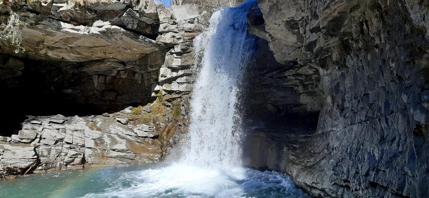
Cascade du Saut de la Pie
Dans les clues de Verdaches, ce site sauvage et enchanteur, avec sa cascade, ses plantes et ses curiosités géologiques, vous offrira un moment de fraîcheur et d’émerveillement. L’atmosphère unique de ce lieu est due à un ensemble d’éléments : roches, lumière, végétation… Sur le plan géologique, on peut y observer une « lacune » et […]

© L'Aventure Géologique
Le Parc Demontzey
Ce parc doit son nom à l’ingénieur Prosper Demontzey, qui fut le grand artisan de la restauration des terrains en montagne dans les Alpes du Sud. Les Alpes du Sud ont été pendant des siècles la proie de l’érosion à cause de la disparition quasi-totale de la forêt sous l’action de l’homme. Dans la seconde […]

© ©UGPH
Le pas de l’Echelle
Le panorama du Pas de l’échelle raconte le temps long de la Terre. Il est l’un des paysages emblématiques du Géoparc de Haute-Provence, aussi beau qu’instructif et inspirant. L’histoire géologique locale est marquée par la succession de périodes marines, par la surrection des Alpes et par une forte érosion. Le panorama du pas de l’Echelle […]

© ©Michel.Boutin
La source de Fontchaude
Cette source, à température constante, se trouve entre les Clues de Barles et de Péouré cœur du Géoparc de Haute-Provence. La source de Fontchaude doit son nom au fait qu’elle ne gèle pas en hiver. Son eau rafraîchit agréablement le promeneur en été. Sa température assez constante est due à un trajet long et profond […]

© ©UGPH
Le ravin de la boulette
Le ravin de la Boulette, sur les flancs du Blayeul, est toujours actif et démontre que l’histoire de la Terre continue de s’écrire et de se lire dans les paysages du Géoparc de Haute-Provence. Ce ravin, en amont de Barles, est un terrain d’observation privilégié des géologues et surprend le randonneur par son étendue. Il […]

© ©MadrigalProd
Les ardoisières de Barles
Au cœur d’un environnement naturel remarquable (Natura 2000), les ardoisières de Barles témoignent d’une situation géologique particulière, unique sur le territoire du Géoparc de Haute-Provence. C’est ici que de la fin du XIXe au milieu du XXe s., les habitants venaient extraire des « lauzes » pour couvrir leurs maisons. Ces lauzes ont remplacé le […]

© ©️AD 04/Martin Champon
Les empreintes de pas d’oiseaux
Quand la géologie devient poésie… Ce site emblématique du Géoparc de Haute-Provence vous permettra d’imaginer quelques oiseaux limicoles promenant sur les plages… il y a 20 millions d’années ! Les sites à empreintes de pas d’oiseaux de la vallée du Bès représentent la capture dans la pierre d’un moment éphémère. Le paysage de l’époque est […]

© AD 04 - Thibault Vergoz
Crête de Géruen
Cette imposante barre rocheuse appartient au massif des Monges, cœur battant du Géoparc de Haute-Provence. Au printemps et au début de l’été, sa flore est un enchantement. La montagne de Géruen est une barre calcaire caractéristique comme nombre de sommets voisins – dont le Rocher des Brigands, tenant son nom d’un passé heureusement révolu ! […]

© AD 04 - N. d'Ortolli Kaléo
La clue de Sisteron
Curiosité géologique, la clue de Sisteron est l’œuvre patiente de la Durance. Elle a été de tout temps l’un des rares lieux de passage entre les Alpes et la Provence. En Provence, le terme clue désigne un passage étroit, creusé par un torrent perpendiculairement à un massif montagneux. La clue de Sisteron se loge entre […]

© Julian Boutron - Unesco Géoparc de Haute-Provence
Pli de Beaujeu
Sur ce territoire du Géoparc de Haute-Provence, les reliefs, comme le pli de Beaujeu, racontent une histoire complexe et mouvementée : celle de la Terre. Parmi les témoignages que les différentes époques géologiques ont laissés, le pli de Beaujeu est remarquable. Situé entre Digne-les-Bains et Seyne, ce pli anticlinal (en forme de pont) illustre les […]

© Laura
La Grosse Pierre
Perché sur une colline au cœur de la vallée de la Blanche, cet impressionnant bloc de grès a été transporté par le glacier dans le bassin de Seyne, il y a plus de 20 000 ans. Lors des grandes extensions glaciaires fini-quaternaires, la glace occupe les vallées nord de l’actuel Géoparc de Haute-Provence. Le glacier […]

© OT Digne LC
Le Vélodrome d’Esclangon
Au cœur de la vallée du Bès et de la Réserve naturelle géologique de Haute-Provence, vivez l’aventure géologique et découvrez l’un des plus beaux points de vue des Alpes de Haute-Provence. Fascinant pour les géologues autant que pour les randonneurs, le Vélodrome est l’un des paysages emblématiques du Géoparc de Haute-Provence. Soulignées par des différences […]

© OT Digne LC
L’Ichtyosaure de La Mélaie
Découvert en 2000, ce reptile marin fossilisé est l’un des derniers représentants des ichtyosaures. Il vivait il y a environ 107 millions d’années, à l’ère secondaire, à l’époque des dinosaures. A Prads Haute-Bléone, entre Chanolles et Chavailles, l’ichtyosaure de la Mélaie témoigne d’une époque où l’eau recouvrait les terres de la région. Le squelette été […]

© Département 04
L’Ichtyosaure de La Robine
L’ichtyosaure de La Robine fut l’un des premiers sites en Europe où un squelette a été conservé et protégé in situ. Il se découvre au terme d’une randonnée accessible à tous et très agréable. L’Ichtyosaure de La Robine est âgé d’environ 185 millions d’années et il présente un très grand intérêt scientifique et pédagogique. Son […]

La dalle aux ammonites
Au cœur du Géoparc de Haute-Provence, la dalle aux ammonites a été placée en 2022 parmi les 100 plus beaux sites du patrimoine géologique international. Sur 350 m², 1 550 coquilles d’ammonites fossilisées, dont les plus grandes mesurent 70 cm de diamètre, ne cesse de susciter l’émerveillement. Ce site est extraordinaire et laisse sans voix les […]

© OT
Les Pénitents des Mées
Dressés comme des sentinelles de pierre au-dessus de la Durance, les Pénitents des Mées sont une curiosité géologique du Géoparc de Haute-Provence, aussi inattendue que spectaculaire. L’érosion a taillé un alignement de piliers et de lames haut d’une centaine de mètres dans du poudingue dit de Valensole (-1,65 à – 8 MA), un conglomérat de […]

© Mika Roux
Les Clues de Barles
En voiture le long de l’incroyable D900, à vélo, à pied et même à cheval, découvrez des paysages extraordinaires et d’incroyables sites géologiques pour un voyage… hors du temps ! Les « clues de Barles » sont en réalité au nombre de deux – Saint-Clément et le Péroué – auxquelles on ajoute la clue de […]

© ©UGPH
Chateaufort
A 15 km de Sisteron, Châteaufort semble hors du temps et s’intègre dans un cadre naturel remarquable, celui des Hautes Terres de Provence et leur longue histoire géologique. Pour gagner Châteaufort, vous emprunterez une petite route creusée dans une roche sédimentaire qui semble plantée comme un décor singulier. Vous déboucherez ensuite sur un village paisible, […]

Le retable de Nibles
Le petit village de Nibles se niche au bord de la Sasse, affluent de la Durance, au cœur des Hautes Terres de Provence. Son église N.-D. de Bethléem recèle des trésors insoupçonnés. Avec son environnement naturel, son clocher-mur qui se dessine sur le ciel bleu de Haute-Provence et les aménagements de son parvis, l’église de […]

© ©UGPH
L’alambic de Mison
Symbole d’une époque révolue, l’alambic de Mison témoigne de l’importance des fruits, au cœur de cette région arboricole, et de la vie de la communauté. Ce vieil alambic en cuivre, fabriqué en 1933, est resté en fonctionnement jusqu’en 1997. Conçu pour être itinérant, il n’a pourtant jamais été déplacé depuis son acquisition ! Et pour […]

© ©OT_Sisteron
Le village de Saint-Geniez
Au cœur du Géoparc de Haute-Provence, le village de Saint-Geniez se découvre dans un cadre naturel remarquable, riche de ses patrimoines. Le village, situé à 1 116 m, est adossé aux massifs du Gouras et du Trainon et protégé par la montagne de Mélan (1705 m.). La commune s’inscrit dans un terroir agricole, forestier et […]

Chapelle Saint-Marcellin
A 800 m du charmant village de Vaumeilh, la chapelle Saint-Marcellin semble en dehors du temps. Dressée sur un plateau, le lieu invite à la contemplation et à la quiétude. Plusieurs implantations religieuses émaillèrent le territoire de Vaumeilh au cours des siècles. Si la plus ancienne remonte à l’Antiquité gallo-romaine, la plus connue est certainement […]

Le Vieil Aiglun
Surplombant la vallée de la Bléone (830 m.), le Vieil-Aiglun et son église Sainte-Madeleine sont un havre de paix et vous offrent l’un des plus beaux panoramas du Géoparc de Haute-Provence. Depuis ce vieux village qui renaît depuis quelques années, vous pourrez observer les reliefs des Préalpes dignoises, du sommet de l’Estrop jusqu’au plateau de […]

Le clocher donjon de Thoard
Monument incontournable de la vallée des Duyes, le clocher-donjon de Thoard s’élance dans le ciel de Haute-Provence et témoigne d’un riche passé historique. Le village perché de Thoard est une étape incontournable de la Route du Temps du Géoparc de Haute Provence. Il se dessine, avec son clocher-donjon reconnaissable, en fond d’une vallée qui a […]

© ©️AD 04/Martin Champon
Le cadran solaire annalématique
Le cadran analemmatique de Thoard est l’un des quarante de ce type existants en France. Amusez-vous à deviner l’heure… en fonction de votre propre ombre ! Ce type de cadran est composé d’une ellipse dessinée au sol sur laquelle sont portées les heures de la journée. L’observateur se place sur le petit cadran en fonction […]

© ©Elsa
Église rupestre de Gaubert
Gaubert et son église semblent protégés par le Cousson, montagne tutélaire du pays dignois. Etiré sur une crête de grès, le village offre une vue superbe sur Digne et sur la campagne environnante. Gaubert fut jusqu’à la fin du XIXe s. une commune indépendante et son histoire est très ancienne. Les pentes entre le Cousson […]

© ©UGHP
Notre-Dame du Rosaire
Construite sur une colline qui domine le village de Mézel et la vallée de l’Asse, cette chapelle se découvre par une promenade très agréable. Sa vieille horloge à aiguille unique est bien visible depuis le village. Notre-Dame du Rosaire (XVIIe s.) est l’ancienne église paroissiale du village primitif de Mézel dont subsistent quelques fragments de […]

© ©UGPH
La galerie de mine
Dans des roches qui sont parmi les plus anciennes du territoire, les quartzites du Trias, on trouve une cavité qui s’ouvre sur le bas-côté de la route ; il s’agit d’une ancienne galerie de mine de galène. Ici, dans la clue de Verdaches, le Bès a taillé sa gorge dans une structure géologique appelée dôme […]

© ©Michel_Boutin
Le Hameau de la Rouine
Dans un paysage caractéristique du Géoparc de Haute-Provence, les célèbres terres noires, ce petit hameau semble hors du temps. La petite chapelle d’allure romane est constituée d’une nef unique et couronnée d’un petit clocheton. Elle a été édifiée à la demande des paroissiens de La Rouine en 1647. Restaurée au XXe siècle par les habitants […]

Notre-Dame de Lauzière
La promenade vers ce site qui domine la vallée de la Bléone est agréable et vous offrira une magnifique vue sur la vallée de la Bléone et les massifs des Préalpes dignoises. Probablement construite au XIIe siècle, Notre-Dame de Lauzière est un excellent exemple de l’architecture romane en Haute-Provence par la simplicité de son plan. […]

© Martin Champon
Eglise Notre-Dame de Bethléem
Etape incontournable de la route de découverte du Géoparc de Haute-Provence, l’église N.-D. de Bethléem, classée Monument historique, est un édifice surprenant. Dans un environnement naturel préservé, au cœur du massif des Monges, le village de Bayons ne manque pas d’attraits, dont son église monumentale ! vous serez surpris par ses dimensions (35 m de […]

© Communauté de Communes Sisteronais Buëch
Authon
Niché dans le massif des Monges, le village d’Authon affiche plénitude et sérénité. Avec ses reliefs et son histoire, il est l’un des villages emblématiques du Géoparc de Haute-Provence. Authon (1 137 m) est niché dans un écrin naturel remarquable. La beauté des paysages et le calme qui s’en dégage invitent au repos et à […]

© OIT Motte Turriers
Tour de Melve
Datée du XIIIe siècle, la tour de Melve faisait autrefois partie d’un système défensif unissant 21 châteaux et tours de guet des Hautes Terres de Provence. C’est une étape de la route des Hautes-Terres du Géoparc de Haute-Provence. La tour est implantée à 900 m d’altitude, sur un relief abrupt qui lui procurait protection naturelle […]

Fontaine de Gigors
Gigors est l’un des villages des Hautes Terres de Provence. Sa fontaine et la meule à plâtre sont des témoignages précieux de la vie d’autrefois. Entre deux randonnées, ou en étape sur la route découverte du Géoparc de Haute-Provence, n’hésitez pas à vous arrêter dans le charmant village de Gigors. La commune fut autrefois une […]

© Office de Tourisme Sisteron Buëch
La Pierre Ecrite
Cette inscription monumentale, datée du Ve siècle, raconte la retraite de l’un des derniers dignitaires de l’Empire romain, Claudius Postumus Dardanus. La Pierre-Écrite est un site d’une grande richesse patrimoniale. Il témoigne d’une époque mouvementée (effondrement de l’Empire, progrès du catholicisme, invasions…), d’une histoire des Hommes mais aussi des qualités d’un territoire qui, de tout […]

© OT BSP
Villages & Cités de Caractère Seyne les Alpes
A 1260 m d’altitude, Seyne est une cité de caractère qui séduit par la richesse de son patrimoine architectural et par un environnement naturel exceptionnel. Hiver comme été, elle est une station de vacances très appréciée. La cité, couronnée par son fort et sa « grande Tour », dévoile ses ruelles et placettes, avec d’authentiques […]

© Office de Tourisme Sisteron Buëch
Pont de la Reine Jeanne
Franchir ce pont de pierre pour enjamber le Vançon, c’est se trouver comme en dehors du temps, dans un cadre naturel remarquable. Idéal pour une balade… au bout du monde ! Le pont relie les hameaux de Vilhosc et de St-Symphorien, tous deux situés sur la commune d’Entrepierres. Autrefois densément peuplés, ils furent sévèrement touchés […]

© José Huguet
Chapelle et crypte de Dromon
Probablement édifiée au XIe siècle, cette chapelle est un véritable lieu spirituel. Elle se niche dans un cadre naturel impressionnant qui invite à l’humilité et à la méditation. Accrochée aux flancs du rocher, N.-D. de Dromon est exceptionnelle par sa crypte du premier âge roman. La chapelle a été restaurée et agrandie en 1682 ; […]

© Thibaut VERGOZ
Le Château de Malijai
Rendu célèbre par le passage de Napoléon, le château de Malijai est un rare et bel exemple de l’architecture seigneuriale du XVIIIe s. sur le territoire du Géoparc de Haute-Provence. Le château présente un plan rectangulaire avec deux façades, l’une côté village, l’autre côté jardin. De chaque côté, deux tours rondes coiffées en éteignoir sont […]

© Jean-Luc ARMAND
Le Château du XVIe de Château-Arnoux
Le château de Château-Arnoux est l’un des fleurons de l’architecture du Géoparc de Haute-Provence. Son escalier classé est remarquable par sa statuaire, unique dans le sud de la France. Construit entre 1510 et 1515, l’édifice est encore médiéval par sa base massive, ses archères à croisillons et ses bouches canonnières. En revanche, son toit vernissé, […]

© OT DLB
Village de Thoard
Dominant la vallée des Duyes, le village de Thoard est bien représentatif de l’habitat groupé de Haute-Provence. Son donjon du XIIIe siècle est remarquable. Thoard – du latin turris ardua, qui signifie tour élevée – fut, durant des siècles, un poste défensif redoutable. Au sommet du piton rocheux, la tour médiévale couronnée d’un clocher est […]

© Paroisse Cathédrale Digne Asse Bléone Duyes
Cathédrale Notre-Dame du Bourg
Avec sa grande rosace, son appareil régulier, sa nef unique et ses quatre grandes travées, la cathédrale Notre-Dame du Bourg est l’une des plus belles églises romanes du sud-est de la France. L’architecture romane est très présente sur le territoire du Géoparc de Haute Provence et compte des édifices remarquables, dont au premier chef, Notre-Dame […]

© Timothée Trichet
Refuge privé de Gaudichart
Le Refuge privé de Gaudichart Au cœur du massif de la Haute-Bléone, Gaudichart est un espace d’accueil écoresponsable situé en pleine montagne à 1300 m d’altitude, avec pour seul accès un petit sentier de randonnée : déconnexion garantie ! Timothée et Laura vous accueillent en petit groupe au cœur de 8 hectares de forêts et […]

© Chaussegros
Ecolodge 04
Gloria « l’Australienne » et Régis « le Bas-alpin, » ont réalisé le pari de transformer une ancienne écurie/grange à l’abandon en une écolodge pour l’accueil de 15 personne : La Pastoulière.

© Chambres d'hôtes : Le Pin des Arches
Chambres d’hôtes : Le Pin des Arches
Profitez d’un séjour confortable au sein de l’établissement « chambres d’ hôtes » : Le Pin des Arches. Grande maison qui dispose d’un jardin de 600m²bien exposé avec vue sur la montagne, au calme Une piscine de 11x5m accessible en saison.

© CMR Fontaine de l'Ours
La Fontaine de l’Ours
Centre de Vacances la Fontaine de l’Ours « Écoutez la nature, ressentez la musique. » Situé à Auzet, dans un petit village de montagne, la Fontaine de l’Ours est un centre de vacances chaleureux et accessible à tous, où la nature et la musique sont à l’honneur. A la croisée des vallées de la Blanche […]

© Julien Defois
Accompagnateur Rando Bivouac Trek – Reconnexion Nature
Reconnexion Nature Reconnexion Nature vous propose une expérience : marcher en montagne pour se reconnecter à l’essentiel. Immergé dans la beauté du Vivant, on ralentit, on se libère des préoccupations du quotidien, on redevient présent et on peut retrouver une joie simple, celle de vivre ici et maintenant. Accompagnateur en montagne installé à Seyne les […]

© Nathalie Le Royer
Gîte T5 Villa Flora
Vue Superbe! Belle villa de 120 m². Vue panoramique sur les montagnes. Jardin et terrasse, cheminée/poêle, dans un hameau charmant au calme, 3km du Golf de DIGNE-LES-BAINS, la préfecture, accrobranche, lac de baignade. À 12 km Spa thermal, Evobike Parc.

© Le Gîte de Roquépine
Le Gîte de Roquépine
Le gîte de Roquépine (écogîte de montagne) est situé à Barles, restauré dans un bâtiment ancien au sein de la ferme équestre Les chevaux de Roquépine. Il a une capacité de 9 personnes (6 adultes et 3 enfants). Très belle vue, calme .
Association Intercommunale de Défense de l’Environnement (AIDE)
L’association AIDE propose des animations afin de sensibiliser la population locale, les visiteurs et touristes à la protection de l’environnement.

© Restaurant Le Mas des Saveurs
Restaurant Le Mas des Saveurs
Sur la place Paul Arène, le restaurant n’a de cesse d’accueillir les amoureux du goût et du plaisir, pour des moments de bonheur et d’émerveillement. Notre restaurant unit tradition et innovation, grâce à l’enthousiasme du Chef et de son équipe.

Cours de pâtisserie à la Boîte à Biscuits
Idéale pour une halte gourmande, la Boîte à Biscuits est un concept original qui combine coffee shop et fabrication en direct d’une large gamme de biscuits. Vous cherchez un lieu chaleureux pour savourer de délicieux biscuits, chocolats, tartes, meringues et prendre une boisson, chaude ou frappée ? Franchissez la porte de la Boîte à Biscuits […]

© Reliefs
Reliefs
Vous recherchez des spécialistes de la randonnée, des raquettes à neige, de la marche nordique ou de la course nature ? Découvrez et pratiquez la montagne en toute saison ! Reliefs est un bureau d’accompagnateurs en montagne, diplômés d’Etat d’alpinisme. Ces spécialistes de la randonnée, du trail et du trek sont aussi passionnés par leur […]

© Office de tourisme
Atelier Bondil
Plongez dans l’excellence et l’élégance de la faïence de Moustiers : l’atelier Bondil perpétue depuis plus de 40 ans, avec rigueur et passion, l’œuvre des maitres faïenciers du XVIIe s. L’Atelier Bondil est un créateur de styles traditionnels et contemporains, labellisé « Entreprise du Patrimoine Vivant » et géopartenaire, c’est-à-dire entreprise engagée au sein du […]

© Adrien Noat
Musée de la Faïence
La faïence produite à Moustiers avait la réputation d’être « la plus fine du royaume » au temps de Louis XIV. Le musée permet de découvrir 5 siècles de chef d’œuvre au travers d’une collection exceptionnelle. Dans une atmosphère propice à la délectation mais aussi à l’éducation et à la connaissance, plus de 300 pièces […]

© Crypte Archéologique Notre Dame du Bourg
Crypte Archéologique Notre Dame du Bourg
Issue de trois campagnes de fouilles, la Crypte archéologique de Notre-Dame du Bourg révèle des traces de construction à l’emplacement exact des origines de la ville de Digne, sur 870 m². En 1980 alors que de longs travaux s’engagent pour sauver et consolider la cathédrale Notre-Dame du Bourg une première campagne de fouilles archéologiques (1987-1988) […]

© DELAFONTAINE Jean-Luc
Gite T2 Halte Air et Go – L’hôte antique
Situé dans le village de Marcoux, au cœur du Géoparc Unesco de Haute-Provence, le gîte Hôte-Antique partage son terrain avec les gîtes Halte Air et Go. Ce lieu est idéalement placé pour explorer les trésors de la région, et peut être réservé pour quelques nuits ou pour un séjour d’une semaine. Depuis le jardin et […]

© Musée Gassendi
Musée Gassendi
Le Musée Gassendi présente des collections encyclopédiques dans le domaine de l’art, de l’histoire locale et sciences physiques et naturelles. Ouvert en 1906, le musée Gassendi se présente comme un lieu d’exposition permanent et évolutif. Il fait partie du pôle muséal Ambulo de Digne-les-Bains. Le visiteur y découvre le dialogue mis en place entre les […]

© ©MadrigalProd
Milefolia
Emeline et Jérôme, deux âmes amoureuses de la montagne et des plantes, ont fait germer Milefolia, une entreprise artisanale de cueillettes et transformations pour vous faire découvrir la richesse des plantes sauvages et leurs propriétés, perpétuant ainsi une longue tradition provençale. Ils cueillent, sèchent, distillent et créent des macérations huileuses avec les plantes pour extraire […]

© ©MadrigalProd
Les Ruchers des Ames Fortes
Cet apiculteur labellisé Bio a installé ses ruches sur les hauteurs de Digne-les-Bains. Depuis Courbons, sur les contreforts du Siron, il produit un miel de montagne, de lavande et de printemps. L’association de l’abeille et de la lavande est une caractéristique de la Haute-Provence : l’action des abeilles augmente le rendement en essence et assure la […]

© SARL Les robines vert-bleu
Appartement T6 Le Château
Châtelains d’un instant, soyez les bienvenus dans ce grand et majestueux gîte au cœur du Géoparc de Haute-Provence, loin du tumulte du monde. Le château de la Robine est un grand mas provençal. Ce gîte de 139m² est conçu pour la convivialité et le partage (il fut une salle de réception puis un bar). Il […]

© SARL Les robines vert-bleu
Appartement T3 Hypocras
Au cœur d’un château rénové avec charme, vous profiterez d’un environnement propice au repos et à la découverte d’un territoire au riche patrimoine naturel et culturel. Nathalie et Frédéric vous accueillent dans ce gîte aux couleurs provençales (55 m²). Au rez-de-chaussée, avec entrée indépendante, il possède une cuisine ouverte sur l’espace repas et salon, deux […]

© Nathalie Le Royer
Gîte T4 Bélà Vista – La Bastida Flora
Dans le petit hameau de caractère Saint-Jurson, le gîte Bélà Vista est situé dans une petite Bastide restaurée du 17ème siècle. Cet élégant appartement possède une superficie de 60 m² avec une terrasse profitant d’une magnifique vue panoramique. Il comprend 2 chambres (une chambre avec 2 lits simples et une chambre avec 1 lit 140), […]

© Franck Le Nedic
Le Jas de Volonne
Idéalement situé pour découvrir la Haute-Provence, le Jas de Volonne vous propose des chambres d’hôtes tout confort au cœur d’un magnifique domaine. Géraldine et Franck vous accueillent dans leur maison provençale aux 4 chambres indépendantes, décorées avec soin. Passionnés de moto, ils sauront vous conseiller les circuits emblématiques ou secrets de leur territoire et vous […]

© DELAFONTAINE Jean-Luc
Gite T3 Halte Air et Go – Cheval Blanc
Gîte bioclimatique écologique avec vue et piscine panoramiques à quelques kilomètres de Digne-les-Bains, au cœur du Géoparc de Haute-Provence. Ce gîte 4* tire son nom de la vue qu’il vous offrira sur la montagne du Cheval Blanc (2323 m). Il vous garantit bien être et séjour écoresponsable dans une construction en matériaux écologiques avec ossature […]

© DELAFONTAINE Jean-Luc
Gite T3 Halte Air et Go – Barre des Dourbes
Gîte bioclimatique écologique avec vue et piscine panoramiques à quelques kilomètres de Digne-les-Bains, au cœur d’un territoire étonnant, entre Alpes et Provence. Ce gîte 4* tire son nom de la vue magique qu’il vous offrira sur cette longue barre calcaire caractéristique du Géoparc de Haute-Provence. Ce territoire, riche d’une histoire géologique mouvementée, vous réserve de […]

© SARL Les robines vert-bleu
Appartement T2 Près des étoiles
Bienvenue sous les toits du château de la Robine ! Entre terre et ciel, au cœur du Géoparc de Haute-Provence, dans un gîte tout confort, vous découvrirez l’un des ciels les plus purs d’Europe. Depuis la cour du mas provençal, vous emprunterez un escalier ancestral qui vous mènera au 3e étage. Vous découvrirez un cocon […]

© SARL Les robines vert-bleu
Appartement T2 La Bergerie
Bienvenue dans ce gîte « pastoral » aménagé au cœur d’un grand mas provençal, dans une vallée préservée qui vous garantit calme et dépaysement. Vous apprécierez ce gîte (45 m²) aménagé avec goût dans un ancien bâtiment agricole aux épais murs de pierres et poutres remarquables. Vous serez plongé dans une atmosphère ancestrale et paisible, […]

© SARL Les robines vert-bleu
Appartement T3 Les Robines
Bienvenue dans ce gîte situé dans l’ancienne grange du château, pour un séjour au calme au cœur du Géoparc de Haute-Provence : idéal pour se ressourcer ! Ce gîte, rustique et campagnard, vous accueille face aux « robines » du même nom, ces collines de marnes noires caractéristiques du territoire. Il garde quelques vestiges de […]

© SARL Les robines vert-bleu
Appartement T4 Le Fournil
Tribus ou familles nombreuses, rechargez les batteries dans ce gîte pour 10 personnes au cœur d’un environnement naturel exceptionnel ! Nathalie et Frédéric vous accueillent dans leur mas rénové, niché au creux de l’une des vallées du Géoparc de Haute-Provence. Vous découvrirez des paysages témoins d’une riche histoire géologique (comme les Robines ou Terres noires) […]

© SARL Les robines vert-bleu
Hébergement Insolite Le Pigeonnier
Bienvenue dans ce gîte de charme pour roucouler à deux puis partir à la découverte du Géoparc de Haute-Provence et de ses paysages étonnants. Vous craquerez pour ce nid adorable (25 m²), restauré dans la forme des pigeonniers provençaux, avec sa toiture en cascade et ses carreaux de céramique. Cette petite tour, dressée comme une […]
Gîte T3 La Bédigue La Ferme du Château
Découvrez ce gite à la ferme au cœur du Géoparc de Haute Provence : authenticité, dépaysement et sérénité garantis ! Dans le hameau de Lambert, vous découvrirez un environnement préservé, à quelques pas du massif des Monges. Le gîte est attenant à une exploitation traditionnelle de moyenne montagne où Alessia et Jérôme élèvent chèvres, brebis, […]

Gîte T2 Le Cabro La Ferme du Château
Au cœur du Géoparc de Haute-Provence et d’une exploitation traditionnelle, ce gîte est idéal pour un retour aux sources et la découverte de la nature, pour petits et grands ! Le Cabro (chèvre en provençal) est situé dans le hameau de Lambert, en pleine nature, avec des airs de bout-du-monde ! Il est attenant à […]

© Lou Cèu Sin
Lou Cèu Sin
A 8 km de Sisteron, ces deux chambres d’hôtes au cœur d’un environnement exceptionnel vous attendent avec piscine, jacuzzi, sauna… et la nature à portée de main ! En provençal, lou ceu sin signifie ciel serein. Au cœur du Géoparc de Haute-Provence, vous profiterez d’un environnement naturel exceptionnel : paysages étonnants, richesse faune/flore, air pur […]

© Hautes Terres de Provence
Luc Richard – Randonnée art montagne
AMM diplômé d’État, guide d’art en montagne et spécialiste de la survie en milieu naturel, Luc Richard vous propose une immersion dans la nature et la culture du surprenant massif des Monges, cœur battant du Géoparc de Haute-Provence. Passionné de montagne (originaire du Queyras), de voyages, d’écologie, d’ethnobotanique mais aussi d’histoire et de littérature (il […]

© CHAPON Laurent
Gîte T4 La Maison blanche
Dans la vallée de la Bléone, cette maison individuelle spacieuse et fonctionnelle est idéalement placée pour découvrir le Géoparc de Haute-Provence et la région. Ce chaleureux gîte rural 4 étoiles, proche de Digne-les-Bains, vous permettra de rayonner sur l’ensemble du département. Dans un environnement reposant, vous apprécierez l’espace à vivre de 67m² (salon, salle à […]

© AdrienQuintana
Flower camping Le Clôt du Jay
Idéalement situé à Clamensane, dans une vallée préservée du Géoparc de Haute-Provence, le Clôt du Jay vous promet un séjour et des découvertes inoubliables dans un cadre naturel exceptionnel, avec la nature à portée de main. Nadège et Éric vous accueillent dans leur domaine de six hectares avec des emplacements spacieux, des chalets et des […]

© Office de tourisme Sisteron Buëch
Musée Édith-Robert – Musée Terre et Temps
Au cœur de la ville de Sisteron, ce musée retrace la mesure du temps de l’Homme et du temps de la terre. Il est une étape sur la route du temps du Géoparc de Haute-Provence. Dans l’ancienne chapelle du couvent des Visitandines du XVIIe s., inscrite au titre des Monuments historiques, vous découvrirez divers instruments […]

© Office de Tourisme Sisteron Buëch
Musée Gallo-Romain
Au cœur de la ville de Sisteron, le musée gallo-romain présente des pièces exceptionnelles et une exposition permanente sur les rites funéraires et l’histoire antique de la ville. Segustero était une cité romaine, située au carrefour de routes importantes, dont la Via Domitia. Ce musée retrace cette histoire antique et propose un parcours composé de […]

Écomusée du Pays sisteronais
L’écomusée du Pays sisteronais présente une collection permanente et un nouvelle exposition temporaire chaque année. L’exposition temporaire 2024 : « La menuiserie des années 1900 et le Pont de la Baume ».

© Susy Géna-Podesta
Camping Les Prairies***
Situé dans un cadre unique, au cœur de la vallée de La Blanche, ce camping est idéal pour les amateurs d’espace et de nature. Vous y trouverez calme, confort et détente dans une ambiance familiale. La vallée de la Blanche est la plus alpine des vallées du Géoparc de Haute-Provence et offre des lieux sublimes […]

© Charles SPETH
Gîte du Levant (T3) – Le Vieil Aiglun
Perché sur le contrefort d’une colline, le Levant est un gîte de charme indépendant, au cœur d’un domaine du XVIe siècle, avec grand jardin privatif, vue et piscine panoramique. En 2003, Annick et Charles Speth (également accompagnateur en montagne) ont le coup de foudre pour le Vieil-Aiglun, village abandonné de Haute-Provence. Ils décident de lui […]

© Charles SPETH
Gîte du Couchant (T3) – Le Vieil Aiglun
Surplombant la vallée de la Bléone, ce gîte de charme indépendant vous assure calme et dépaysement, avec vue et piscine panoramiques. En 2003, Annick et Charles Speth (également accompagnateur en montagne) ont le coup de foudre pour le Vieil-Aiglun, village abandonné de Haute-Provence. Ils décident de lui redonner vie et en font un paradis : […]

© Charles SPETH
Gîte du Midi (T5) – Le Vieil Aiglun
Au cœur d’un hameau restauré, grand gîte de charme (modulable) avec vue et piscines panoramiques, articulé autour d’une cour abritée. En 2003, Annick et Charles Speth (également accompagnateur en montagne) ont le coup de foudre pour le Vieil-Aiglun, village abandonné de Haute-Provence. Ils décident de lui redonner vie et en font un paradis : 3 […]

© Christine Collieux
Appartement T3 Le Galabre
Appartement T3 Le Galabre Depuis ce gîte adossé à la montagne, vous profiterez d’un environnement exceptionnel et partirez à la découverte du Géoparc de Haute-Provence, de ses paysages et de ses patrimoines. Entre amis ou en famille (4 pers.), vous découvrirez un logement tout confort au cœur d’une vallée sauvage qui tire son nom du […]

© Camping Les Eaux Chaudes
Camping Les Eaux Chaudes
Proche des thermes de Digne-les-Bains et des parcours de randonnée et de VTT dans les Terres Noires, le camping Les Eaux Chaudes vous propose des locations de mobil-homes et des emplacements délimités, aménagés et ombragés. Vous souhaitez partir à la découverte du Géoparc de Haute-Provence ou profiter d’une halte détente/santé à Digne-les-Bains ? Le camping […]

© Hôtel Le Saint Michel
Hôtel Saint Michel
A 4 minutes du centre-ville de Digne-les-Bains, l’hôtel Saint-Michel est une halte agréable sur la route Napoléon. L’hôtel Saint-Michel dispose de 20 chambres tout confort, avec wifi gratuit. L’établissement se situe entre la gare et le centre commercial, à proximité de nombreux services et commerces. Le très agréable plan d’eau de Digne-les-Bains est à quelques […]

© Pixabay
Association Intercommunale de Défense de l’Environnement
L’association AIDE propose des animations afin de sensibiliser la population locale, les visiteurs et touristes à la protection de l’environnement. Crée initialement pour faire face au projet de carrière de gypse à Bayons, l’Association Intercommunale de Défense de l’Environnement se positionne aujourd’hui dans le secteur des Hautes Terres autour du massif des Monges autant comme […]

© Office de tourisme Sisteron Buëch
Pasta Durance
Des pâtes artisanales, savoureuses et bio pour petits et grands ! Made in » Alpes du Sud » ! Anne Cécile confectionne ses pâtes à partir de farines Bio de Haute-Provence. Elle apporte une grande attention à chaque étape de la fabrication, depuis la sélection des variétés (digestibilité, sensibilité au gluten) jusqu’au séchage à basse température […]

Chef Frédéric Payan- Cuisine et terroir
Cuisine et terroir vous propose de créer des événements culinaires autour de notre Terroir des Alpes de Haute Provence. Repas insolites, démonstrations culinaires, événements autour de notre patrimoine culinaire… bref venez proposer votre idée et nous construiront ensemble votre événement. payanfrederic.wixsite.com

© Tis anes
Tis’ânes, Séjours Nature Alpes et Luberon
Avec Tis’Ânes, retrouvez votre âme de nomade et partez à la découverte des territoires préservés de Haute-Provence et des Alpes ! Tis’Ânes vous propose des balades à la journée ou des séjours en itinérance dans la vallée de la Blanche, près du lac de Serre-Ponçon, et dans le Lubéron. Félix, Jonquille, O’Malley, Chocolat et quelques […]

© GAEC l’Étoile du Berger
GAEC l’Étoile du Berger & Association pour la promotion de la Poire Sarteau de Draix
La poire Sarteau blanche de Draix : un patrimoine à part entière et un pur délice à découvrir, en fruits confits, jus de fruits ou en tartes et gâteaux. Les grands poiriers semblent se prélasser au soleil sur les piémonts du Géoparc de Haute-Provence, à Draix très exactement, en Haute-Bléone, au plus près des robines. […]

© Mireille Raimondez
Le 28
Tapas et bar à vin le soir. Cave à vins. Concept original d’une cave à vin proposant une dégustation de vins au verre et de spécialités d’ici et d’ailleurs sous forme de tapas revisitées le soir.

© © autres versants
Autres versants – Accompagnateur en montagne – Simon De Bergh
AUTRES VERSANTS – Accompagnateur en montagne – Simon De Bergh Découvrir les « Autres Versants » de nos montagnes, ceux que l’on connait moins, c’est possible ! Simon de Bergh vous propose des randonnées guidées autour de Sisteron, entre Alpes et Provence. Professionnel des activités de pleine nature, Simon organise des balades thématiques, randonnées et bivouacs dans […]

© Bleu d'Argens
Bleu d’Argens – Distillateur de bonheur
Au cœur du Géoparc de Haute-Provence, plongez dans un univers de senteurs et découvrez une gamme de produits 100% naturels. Véronique vous accueille dans une belle bâtisse centenaire pour vous faire découvrir sa passion et son activité. Vous découvrirez une exploitation exemplaire et vous saurez tout sur la lavande, de la graine ou de la […]

© Le Dromon
Restaurant Le Dromon
Une étape culinaire sur la route du temps : découvrez une cuisine maison qui fait la part belle aux produits locaux dans un environnement préservé. Le Dromon vous accueille dans une vallée secrète, aux paysages magnifiques. Cette halte gourmande et reposante, au cœur du massif des Monges, sur la route du Temps du Géoparc de […]

© La Robine des Canards
La Robine des Canards
Cette exploitation agricole familiale élève des canards gras sous le soleil de Provence et propose une gamme de produits frais ou en conserve. Au cœur des robines, ces terres noires caractéristiques du Géoparc de Haute-Provence, Clément s’est lancé dans l’élevage de canards et transforme sur place. Il a été rejoint par sa femme, Jessica, en […]

© L'Auberge Montagnarde du Fanget
L’Auberge Montagnarde du Fanget
Restaurant traditionnel midi et soir, en fonction des jours d’ouverture, et aussi service snack/bar pour les petites faims et en-cas à emporter. Produits frais et locaux, cuisine maison et généreuse. Sur réservation. Nous avons pour objectif de vous accueillir dans une ambiance montagnarde conviviale en accord avec nos valeurs : à travers notre cuisine servie […]

© O.Trioux
Vannerie sauvage et Bois
Situé sur la commune de Mison, sur la route du vieux village, Vannerie sauvage et bois est l’un des géopartenaires du Géoparc de Haute-Provence. Olivier Trioux travaille le bois sous toutes ses formes : objets utilitaires (cuillères, bols…), décorations intérieures et extérieures. Il partagera sa passion du bois et de ce territoire singulier dans lequel […]

© la grande fistoire d'Annie
La grande fistoire d’Annie
Située dans les Alpes-de-Haute-Provence, dans l’UNESCO Géoparc, une maison de caractère rénovée à l’esprit montagnard où Annie et Jean-Marc vous accueillent. Ils proposent aussi leur table d’hôte avec une cuisine savoureuse et généreuse. Maison qui se compose de 6 chambres et d’une salle à manger. Vous avez le choix de 3 chambres avec sanitaires privés […]

© La Ferme du Rouveyret
La Ferme du Rouveyret
Née en 2011 au pied du Siron, dans le vallon du Rouveyret (Digne-les-Bains), la ferme élève des vaches de race Aubrac et des agneaux, en plein air et en « Agriculture Biologique ». Stéphane Estublier est un passionné. Après des études agricoles, il intègre les services municipaux de Digne-les-Bains tout en gardant un rêve d’enfant […]

© KARKAM SAFRAN
Le Cabanon
Dans la vallée secrète et magnifique des Duyes, vous apprécierez le calme de cette petite maison aménagée dans le respect de l’habitat ancien de Haute-Provence. Vous souhaitez voyager écoresponsable et bénéficier d’un cadre aussi esthétique qu’authentique ? Le Cabanon est fait pour vous ! Transformé en maison passive et écologique, il vous charmera avec son […]

© Joelle Stordeur
Le Champ des Ombelles
Cette ferme florale est située à Ainac et vous propose des fleurs fraîches ou séchées. Le hameau se situe aux portes des Monges, massif emblématique du Géoparc de Haute-Provence. Des fleurs et du rêve ! Si vous montez jusqu’au champ des ombelles, vous trouverez un enclos rempli d’une centaine de variétés de fleurs qui poussent […]

© Le Maurier-Van Der Ham Christine
Le Maurier
Le Gîte Rural Le Maurier au rdc de la maison maître propose un hébergement calme et confortable T2 pour 4 personnes. Complètement équipé et avec son jardinet privé, ce gîte traditionnel est le point de départ idéal pour explorer les merveilles de l’UNESCO Géoparc, le Lac Serre Ponçon et les paysages et petites villes et […]

© OT BSP
Le Fort Vauban de Seyne
La Citadelle Vauban de Seyne témoigne de l’histoire de la vallée depuis le XVIIe siècle. Elle vous offrira également un panorama superbe sur la chaîne de la Blanche et sur cette vallée alpine. La citadelle proprement dite a été construite en 1693. Le royaume est alors menacé par la Savoie voisine et Seyne est ville-frontière. […]

GAEC La ferme du Château
Dans le hameau de Lambert (commune de La Robine), venez découvrir cette ferme traditionnelle de moyenne montagne : élevage caprins et ovins, transformation laitière et fromagère. Sur ce territoire, au cœur du Géoparc de Haute-Provence, le pastoralisme est intimement lié aux paysages, aux reliefs, aux sols et bien sûr au climat. A quelques pas du […]

© Marie France GIRARD
Le Vieux Moulin
Visite personnalisée, gratuite de l’ancien moulin à huile familial par l’oleicultrice. Découvrez la culture authentique de l’olive et du lavandin, les produits ancestraux de notre belle Provence.

© ©AD04 Foehn Photographie
Brasserie de l’Aubrée
Au cœur de la vallée de la Blanche et du village de Selonnet, découvrez des bières artisanales de caractère et explorez un univers riche en goûts, en tradition et en histoire. Ici, tout est affaire de passion et de savoir-faire : chaque brassin est comme une œuvre d’art, unique, qui reflète la personnalité et l’ingéniosité […]

© Lou Cèu Sin
Gîte Lou Cèu Sin
A 8 km de Sisteron, sur la commune d’Entrepierres, vous bénéficierez d’un espace de sérénité, tout confort, dans ce gîte indépendant, avec piscine, jacuzzi et sauna en pleine nature. En provençal, lou ceu sin signifie ciel serein. Vous profiterez d’un environnement naturel exceptionnel : paysages étonnants du Géoparc de Haute-Provence, richesse faune/flore, air pur et […]

© Louis Teyssier
Accompagnateur randonnée Louis Teyssier
Depuis le site du Fanget, Louis Teyssier propose de véritables évasions au cœur du milieu naturel montagnard de la Blanche, du lac de Serre-Ponçon et de l’Ubaye. Passionné depuis son plus jeune âge, Louis Teyssier veut partager le « bonheur de la montagne ». Basé sur le site du Fanget, site nordique de pleine nature, […]

© Marine Herbomez
Ferme équestre Les Chevaux de Roquépine
TREC, balades et randonnées à cheval ou poney et promenades en calèche : prenez le temps de découvrir l’une des vallées emblématiques du Géoparc de Haute-Provence, la vallée du Bès. Les Chevaux de Roquépine est une ferme équestre affiliée à la Fédération Française d’Équitation. Les Chevaux (Franches, Montagnes, PaintHorse, Welshes) vous emmèneront à la découverte […]

© rose-marie garcin
Les trésors de nos montagnes
A la découverte de l’or rouge de Haute Provence : production locale de safran, de truffes, et produits dérivés à base de fruits à Bayons, au cœur d’un territoire préservé. Rose-Marie et Florent vous accueilleront sur leur exploitation. Ces agriculteurs engagés vous parleront de leurs productions, issues de cultures respectueuses de l’environnement, de cueillettes sauvages […]

© Charles Speth
Hiking France
Hiking France vous propose une découverte des paysages et des richesses secrètes de la Haute-Provence et des Alpes du Sud avec des randonnées et excursions mêlant nature, géologie et art. Accompagnateur en moyenne montagne, Charles Speth vous guidera vers les plus beaux sites du Géoparc de Haute-Provence. Pour quelques heures ou quelques jours, vous partirez […]

© Ferme des Sagnes
Ferme des Sagnes
Exploitation ovine de montagne : Agneaux, chevreaux. Visite découverte de la ferme et de ses produits. Vente (agneaux découpés & emballés, saucisses, merguez) toute l’année sur commande et sur les marchés de producteurs de la Motte du Caire, Estoublon, Clamensane (en été)

© CCSB
Via Ferrata de la Grande Fistoire
Prenez de la hauteur avec la Via Ferrata de la Grande Fistoire ! Internationalement réputée pour son parcours aérien, elle vous entraînera à la conquête d’une paroi de 250 mètres, avec une vue à couper le souffle… Au cœur du Géoparc de Haute-Provence, caractérisé notamment par de grandes barres calcaires (-150 millions d’années), la Grande […]

© OIT Motte Turriers
Les produits de l’Adoux
Dans une vallée secrète et préservée, vous découvrirez une gamme de produits 100% naturels issus de plantes sauvages ou cultivées : huile essentielle de lavande fine, hydrolats, confitures, sirops… On peut observer la cueillette et la culture des plantes aromatiques dans l’ensemble des vallées du Géoparc de Haute-Provence où elles bénéficient d’un terroir et d’un […]

© L'Art en Chemin
L’Art en Chemin
Cette association d’accompagnateurs en montagne et d’hébergeurs conjugue art et randonnée au cœur du Géoparc de Haute-Provence. Unis par des valeurs et une passion commune pour leur territoire, ces accompagnateurs (une vingtaine) proposent une découverte différente du Géoparc de Haute-Provence, axée sur l’art contemporain et la rencontre de tous les patrimoines du territoire, naturels et […]

Gîte de Provence – La Robine
Au cœur du massif des Monges, le gîte La Robine est idéalement placé pour découvrir le Géoparc de Haute-Provence, pratiquer des activités de pleine nature et se ressourcer. Rénové avec goût, ce gîte de 70 m2 est au centre du village de Bayons. Vous bénéficierez d’un environnement propice au ressourcement, avec une grande terrasse et […]

© Fabrice Santangelo
Dinovol Parapente
Prêts à déployez vos ailes ? Dinovol Parapente vous propose des vols découverte et des baptêmes en parapente biplace avec un guide-moniteur diplômé d’Etat. Il est temps de prendre de la hauteur ! N’attendez plus et envolez-vous dans le ciel lumineux des Alpes du Sud. En toute sécurité avec des professionnels passionnés et expérimentés, vous […]

© THEAUDIN Yvan
Mandala Voyages
Installé à Prads-Haute-Bléone, Mandala Voyages vous emmène à la découverte des richesses naturelles et culturelles du Géoparc de Haute-Provence dans un esprit zen et d’aventure. Habitué des trekkings himalayens, Yvan Théaudin est accompagnateur en montagne depuis plus de vingt ans et porte depuis toujours des valeurs humaines fortes. « RESPECT, c’est notre point de départ […]

© Office de Tourisme Provence Alpes Digne-les-Bains
Via Ferrata du Rocher de Neuf Heures
Partez à la conquête d’une falaise vieille de plusieurs millions d’années ! La via ferrata du Rocher de neuf heures vous promet sensations et souvenirs inoubliables. Son parcours, ludique et varié, est exposé sud-est et offre plusieurs itinéraires. Il est classé d’assez difficile à difficile (750 m, durée de 50 mn à 4 h) et […]

© Yvan Théaudin
Camping Mandala
A 25 km de Digne-les-Bains, au cœur du Géoparc de Haute-Provence, le camping Mandala vous accueille dans un cadre naturel exceptionnel et préservé. Le camping Mandala est un camping nature qui respecte l’environnement : idéal pour le ressourcement et la pratique d’activités de plein air (randonnée, Via Ferrata, VTT, escalade, canyoning, vol libre…) ! Une […]

© LeNaturographe
Via Ferrata de la Falaise de Meichira
À 30 minutes de Digne les Bains, la Via Ferrata de Prads-Haute-Bléone est la plus alpine des via ferrata du Géoparc de Haute-Provence. Sensations garanties ! Avec un départ à 1000 m d’altitude et 300 m de dénivelé, cette via ferrata vous fera prendre de la hauteur ! Le parcours (longueur de 600 m et […]

© Jérôme et Isabelle DENIER
GAEC La Tchiote Bédigue
Entre Alpes et Provence, au cœur de la vallée de la Blanche, venez découvrir les produits laitiers et la viande d’agneaux de cette ferme familiale. La ferme de Jérôme et Isabelle est située au cœur du Géoparc de Haute-Provence, un territoire où le pastoralisme est une activité importante. Sur cette terre de transhumance, on élève […]

© La Bonne Etape
Restaurant La Bonne Étape
Sur la Route Napoléon, voici une adresse incontournable : l’hôtel Relais & Châteaux et son restaurant gastronomique étoilé Michelin vous attendent pour une expérience unique en Provence. Michelin depuis 1964, cet établissement tenu par la famille Gleize depuis 4 générations vous propose 18 chambres climatisées, au confort raffiné, avec vue sur les montagnes, le jardin […]

© Georges Eric MARTIN
Villa Gaïa Hôtel & Pension
Le charme d’une maison de famille du XIXème siècle au cœur d’un grand jardin pour un séjour en hôtellerie classique ou en résidence. Depuis 1993, Anne-Françoise et Georges-Eric vous accueillent dans leur maison au cœur d’un grand jardin situé à proximité du plan d’eau des Ferréols. Les chambres sont claires et spacieuses, toutes équipées de […]

© Écomusée La Javie Autrefois
Ecomusée La Javie
L’écomusée La Javie présente la vie du village et de la Haute Bléone autrefois et propose un véritable voyage dans le temps à travers 8 expositions à thèmes. Entrée gratuite. Depuis plus de vingt ans, l’association la Javie Autrefois s’emploie à reconstituer l’histoire et les modes de vie ancestraux de la Haute-Bléone. En lien avec […]

© Pascale Giordano
Hôtel-Restaurant Le Vieux Tilleul**
Au pied de la citadelle de Seyne, cette ancienne ferme et son restaurant bistronomique sont une étape incontournable dans la vallée de la Blanche, à découvrir en toutes saisons ! Au cœur d’un grand parc arboré qui longe la rivière, le Vieux tilleul est un havre de paix entre Alpes et Provence. Pascale Giordano en […]

© Hôtel Le Tivoli
Hôtel Le Tivoli
Sur la route Napoléon, le Tivoli sera une halte idéale. Depuis Sisteron, vous partirez à la découverte de la Haute-Provence, de son patrimoine et de sa nature préservée. Fondé en 2012, cet hôtel 2* dispose de 16 chambres tout confort et vous assure un accueil aussi chaleureux que professionnel. Au pied de la Citadelle, l’hôtel, […]

© Florence Michel
Hôtel-Restaurant Chez Le Poète**
Au cœur du village de Selonnet, entre le massif des Monges et la chaîne de la Blanche, vous pourrez goûter aux spécialités locales et apprécier une ambiance simple et familiale. Les plats du Poète vous réchaufferont après une sortie en raquettes, une descente à ski ou en luge, une randonnée ou une balade familiale. En […]

© Volpes Patrick
Santons Passion Patrick Volpes
Patrick Volpes, maître artisan santonnier, crée et façonne une multitude de personnages hauts en couleur. Venez découvrir son atelier-boutique « Santons-Passion », sa crèche animée et son musée. A Champtercier, Patrick Volpes donne libre cours à sa passion depuis 40 ans. Toujours en quête de nouveaux personnages, il puise son inspiration dans la nature sauvage […]

© Christine COLLIEUX
Gîte Lavande
Au sein d’une vallée sauvage et préservée, ressourcez-vous en Haute-Provence et découvrez une terre de lumières et de contrastes ! Voici une vallée singulière : des paysages étonnants, fruits d’une histoire géologique mouvementée, des sites classés (Dalle aux ammonites et ichtyosaure.), un ensoleillement généreux et le sentiment d’être un peu à l’écart du monde. Ce […]

© Marie France Girard
Le Vieux Moulin
Au cœur de la vallée de l’Asse, venez visiter un ancien moulin à huile et découvrez les productions : huile d’olive, huiles essentielles et fleurs séchées. Dans un lieu chargé d’histoire familiale, chez le producteur, vous découvrirez un lieu, une (des) histoire(s) et des produits. Les procédés d’extraction, ancestraux et modernes, n’auront plus de secrets […]

© F. & M. MARION
Camping du Moulin de Thoard
Situé à 900m du village perché de Thoard, le camping du Moulin se découvre dans un écrin de nature, au cœur du Géoparc de Haute-Provence, sur la Route du temps… Dans une société en perpétuel mouvement, vous apprécierez ce camping niché dans une vallée qui a su garder son identité. La vallée des Duyes vit […]

Les Ruchers de la Bastide Blanche
A Estoublon, dans une ambiance toute provençale, venez découvrir les Ruchers de la Bastide blanche et déguster ses miels parfumés. Une étape sensorielle et olfactive sur la route des Galets du Géoparc de Haute-Provence. Vous êtes ici sur la commune d’Estoublon, à quelques kilomètres du célèbre plateau de Valensole et de ses immensités bleu lavande. […]

© Alix De Larminat
Gîte de Flagustelle
Le gîte de Flagustelle est un gîte de groupe et de séjour, idéal pour les activités de montagne, en gestion libre et demi-pension. Le gîte de Flagustelle est aménagé dans l’ancienne école du village de Verdaches. A 1100 m d’altitude, entre Alpes et Provence, son emplacement vous permettra de découvrir un territoire sauvage et préservé, […]

© Karkam Safran Pigment Noir
Karkam Safran de Provence
Dans un lieu préservé et authentique, Guilène vous ouvre les portes de son exploitation où les fleurs de safran s’épanouissent le long des murets en pierre sèches qui diffusent la chaleur estivale. Sa ferme est polyvalente, elle pratique la cueillette raisonnée des plantes aromatiques et médicinales et ses cultures sont conduites en agriculture biologique et […]

© ©VCC04-Thibaut Vergoz
La Maison du Mulet
À mi-chemin entre un musée, un parc d’animation et une ferme pédagogique, la Maison du Mulet permet de découvrir de façon ludique et originale les mulets et leur place dans l’histoire du Pays de Seyne. Mules, ânes et juments pâturent sur le site qui se compose d’une mini-ferme et d’une aire de jeux. Le patrimoine […]
Thèmes
Géopartenaires


